Article Index
Invasive Species
Invasive species can be plants, bacteria, insects, or other animals - anything that does not come from the ecosystem it is residing in. Some species were brought by mistake by mistake, often hitching a ride on cargo or being dumped in ballast waters from ships, while others are from ornamental plants that grew out of control. Read up about some of the common invasive species that can be found in New York:
Common Invasive Species in New York
How to Manage the Invasions
iMap Invasives Reporting
The Rensselaer Land Trust has joined the ranks of citizen scientists to increase knowledge and control of invasive species—a major threat to ecosystem health. As a reporting organization in iMap Invasives, a nationwide database inventory and mapping tool, we provide information about the location of known invasive species and track our control efforts at two specific locations—our Staalesen Preserve and the Hoosic River in Johnsonville.
iMapInvasives New York is New York State's on‐line all‐taxa invasive species database and mapping tool. The comprehensive database can be and is used for:
- the collection, distribution and analysis of invasive species observation, survey, assessment and treatment data
- the coordination of early detection and rapid response efforts through email alerts
- analysis in GIS and modeling programs
It is easy to become a reporter to the database and we encourage our members to do so as Rensselaer Land Trust affiliates at http://imapinvasives.org/nyimi/report_invasives/. You don’t need a login account to make a report. You will need a picture of the plant or insect you are reporting, GPS coordinates if known (Google maps can provide), and to answer some basic questions about the location, size of the infestation, and time that the observation was made. You can get greater access to the database and its reporting capabilities by obtaining a login account. There are two levels of training and access available—a simple on‐line tutorial and quiz gives you basic access and gets you added to the e‐mail list, and a half‐day in‐person training offered once a year gives you certification at more in‐depth levels.
The database is managed by the Natural Heritage Program in cooperation with Partnerships for Regional Invasive Species Management (PRISM), and is funded by the Environmental Protection Fund (EPF).
Hoosic River Water Chestnuts
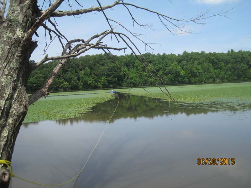 Rensselaer Land Trust owns and operates a public canoe and kayak boat launch about eight miles upstream from the Johnsonville Dam on the Hoosic River in Rensselaer County. The logical place for users of our facility to pull out is the public boat launch on River Road that is associated with the Dam and is owned by the Brookfield Renewables Company. Over the past ten years, this boat pull‐out has become increasingly choked with the invasive plant species known as water chestnut (Trapa natans), making it very difficult to navigate. This plant is spread by seed and is most effectively controlled through physical hand pulling over a period of five to ten years, as the seeds can remain viable for up to 12 years.
Rensselaer Land Trust organized our first annual “Water Chestnut Pull Out Day” on June 20, 2015. (See our events calendar for upcoming annual work dates that are usually scheduled in June or July) This was timed to occur before seeds are set, to help stem the further dispersal of the infestation. We succeeded in attracting about 40 volunteers over the course of the day, and successfully cleared a channel approximately 10 feet wide and 500 feet long to provide access to the boat launch.
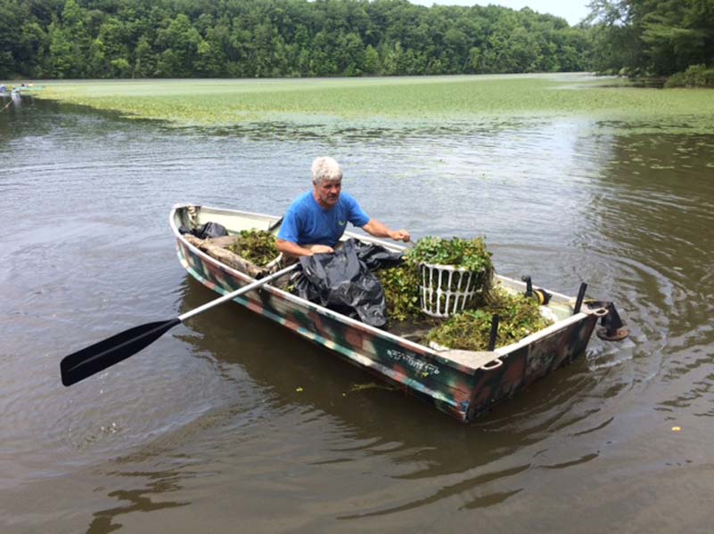 The Hoosic River Watershed Association (http://hoorwa.org/) based in Williamstown, MA, joined the effort as a co‐sponsor, and provided volunteers. We partnered with the Johnsonville Fire Department Ladies Auxiliary to provide food, beverages, and access to bathrooms at the firehouse over the course of the day. We hired Hannan Waste Disposal, a local Poestenkill company, to haul away the full 12‐yard dumpster of material to CTI Agri‐Cycle in Buskirk—a commercial composting facility—where it was composted at high heat. The composted material will be distributed only to farmers with fields that are not in proximity to water. These local partnerships, connections and contributions to the local economy were established to support the multi‐year effort that will be required to keep the navigation channel open. We purchased waders and collection baskets, materials for a boat washing station, and a 600 foot floating rope with buoys that was used to focus volunteer efforts on a navigation channel.
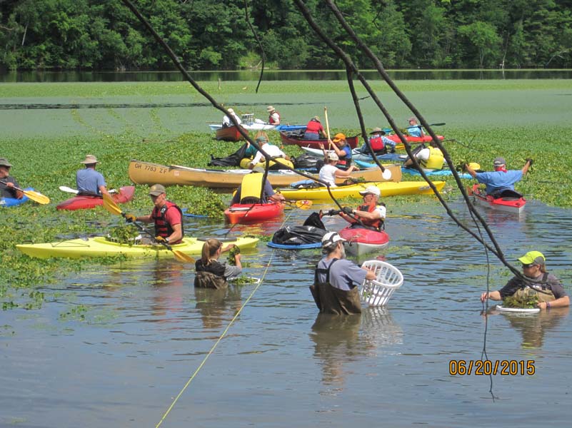
We learned a lot this first year. However, establishing anything other than a narrow navigable channel is probably not realistic without mechanical harvesting. We are observing that in addition to the boat access that the channel is providing, the increased linear footage of “edge” on the infestation that is not in the river current is improving fish habitat. Another task accomplished this first year was to record and document the extent of the infestation in a nationwide database of invasive species known as iMap Invasives, which is a tool that we will continue to use to monitor the size of the mat, and to document our control effort and its effectiveness (or lack thereof). All of our research is confirming that without mechanical harvest, the best that we will be able to achieve is the maintenance of access to the launch and not control of the infestation.
Staalesen Preserve Invasive Species Management
With funding from the Louis and Hortense Rubin Community Fellows Program, the Rensselaer Land Trust is partnering with Dan Capuano, Assistant Professor of Biology at Hudson Valley Community College, to develop a plan for managing the invasive species at our John B. Staalesen Vanderheyden Preserve.
The Land Trust is managing the Staalesen Preserve as a park open to the public and as a nature preserve. Our goal is to improve the front portion of the property into a beautiful gathering spot for the public, while also maintaining wildlife and native plant habitat and the natural ecology, especially in the back portion of the property and along the Wynants Kill.
However, preserving the natural ecology of the preserve is challenging. Several invasive plants, most notably Asiatic bittersweet, Japanese knotweed, and Phragmites reed, have established themselves over much of the preserve, and in some areas are the only plants. Invasive plants crowd out native plants, and provide unsuitable habitat for many wildlife species. In initial efforts to improve habitat, more than 300 trees and shrubs have been planted in partnership with NYS DEC, the Hudson River Estuary Program’s Trees for Tribs and the City of Troy. While establishing themselves in the short term, these new trees and shrubs, and more of the existing native plants, are in danger of being replaced by the invasive species if the latter are not controlled.
In order to move forward with restoring the natural ecology of the preserve, an overall plan is needed to guide the control and management of the invasive plant species. Mr. Capuano will lead the effort to develop this plan, and we hope to complete it this year.