As of January 1, 2024, the Rensselaer Land Trust has merged with the Rensselaer Plateau Alliance. For all questions regarding donations, events, land, or other matters, please visit www.rensselaerplateau.org or call 518-712-9211. For questions about the merger, use extension 101 to speak with Jim Bonesteel. You can expect a new name and logo for our merged organization by Spring / Summer 2024 and a new website by the end of the year!
Protect
Protect

The Rensselaer Land Trust has developed a Rensselaer County Conservation Plan that will serve as a “greenprint” of land and water conservation priorities in the county. The Conservation Plan
- identifies the specific resources and values Rensselaer Land Trust and its partners are working to conserve in Rensselaer County;
- objectively map where these resources and values occur or are supported;
- assess which lands and waters contribute most significantly to these resources and values; and
- use this information to prioritize where Rensselaer Land Trust and its partners proactively pursue land conservation projects, focusing on the lands that will have the most significant impact on Rensselaer County’s natural resources, landscapes, and quality of life.
To view RLT's Conservation Plan and town priority maps go to the links at the bottom of this page! Or for a snapshot of the Conservation Plan click HERE for a Story Map View.
This Conservation Plan is the first comprehensive study of this kind for the entire county, and has been developed with input from and in collaboration with public and private partners and stakeholders, including municipalities, community groups, recreation user groups, other conservation organizations, and residents.
The preparation of this Land Conservation Plan has been made possible by grants and contributions from:
- New York State Environmental Protection Fund through:
- The NYS Conservation Partnership Program led by the Land Trust Alliance and the New York State Department of Environmental Conservation (NYSDEC), and
- The Hudson River Estuary Program of NYSDEC,
- The Hudson River Valley Greenway,
- Royal Bank of Canada,
- The Louis and Hortense Rubin Foundation, and
- Volunteers from the Rensselaer Land Trust who provided in-kind matching support.
Background
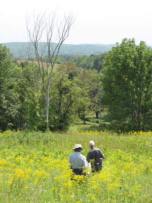
Rensselaer County contains a wealth of open space, natural resources, productive agricultural land, expansive blocks of forest, and other ecologically significant areas, which support wildlife habitat, water quality, recreational opportunities, and sustainable economic activity such as farming, forestry, and tourism. However, Rensselaer County is also experiencing expanding development and proposed activities, including energy infrastructure construction, that threaten or are incompatible with these valuable natural assets and that diminish the ecological services they provide.
A Rensselaer County Conservation Plan serves as a guide not just for Rensselaer Land Trust, but also for our partners in other conservation organizations and municipalities, and for landowners and citizens, in implementing conservation programs and projects. This plan can increase the level of local and regional open space protection by all parties by showing what and where is most important to conserve, fostering activities across political boundaries, leveraging funding, and building community support.
Details
Development of the Rensselaer County Conservation Plan included four phases:
- Inventory. An inventory has been conducted of Rensselaer County’s natural resources, significant open spaces, sensitive environmental features, and lands considered important by local communities. Resources and features include the inventory listed below. Existing GIS and other data, including from partners in this project, have been supplemented with expert and local knowledge, and with information from stakeholders. Solicited community members regarding lands they feel define the special character of their communities, Rensselaer Land Trust conducted four public workshops, and set up an online survey and comment page. Rensselaer Land Trust will reviewed existing municipal open space and natural resource inventories, and reached out to municipalities, community groups, recreation user groups, and other conservation organizations for input into this inventory. Products of this phase with GIS data are provided within the plan.
- Analysis. A spatial analysis has identified those locations in Rensselaer County, and in each individual municipality, that support the highest quality examples of each of these resources, and locations that support high-quality examples of multiple resources. A weighted ranking analysis in a set of lands that contribute the most to the County’s and municipalities’ quality of life and environmental health, and thus are of the highest priority for protection.
- Report. The results of the first two phases are summarized and presented in a published Conservation Plan. The Conservation Plan also includes a section on strategies and recommended actions that can be taken by Rensselaer Land Trust, other conservation groups, municipalities, and landowners for protecting the lands and waters that are identified as priorities.
- Distribution and Outreach. The Conservation Plan will not impact land conservation in the County by just sitting on the shelf. The completed plan is being distributed to all stakeholder groups, partners, municipalities, and the general public; and the results will be presented at public presentations and workshops, and in printed and online outreach materials directed to specific groups.
Resources and features to be included and assessed in the Rensselaer County Conservation Plan:
- Contiguous forest and wetlands
- Water supplies and watersheds
- Wetlands and riparian areas
- Significant ecological communities
- Wildlife and native plant habitat
- Rare plant and animal species
- Prime agricultural lands
- Scenic resources
- Lands with public access
- Historical features and landscapes
- Recreational and tourism features
- Geological features
- Lands valued by local communities
- Lands offering highest level of resiliency for biodiversity to climate change
- Corridors for wildlife and plant movement
While open space inventories and conservation plans have been produced for selected parts of Rensselaer County in the past (most recently the Rensselaer Plateau), Rensselaer Land Trust’s assessment of conservation priorities will be the first to look at all of Rensselaer County. Identification of priority areas for protection will be done at the county level and for each individual town and city.
To view the RLT Conservation Pland and each town's Priority Maps click on the following PDF links:
You may qualify for a federal and New York State Charitable Gift Income Tax Deduction to the extent allowed under law if you donated a conservation easement, and interest in your property, or if you donated all of your interests in your land to Rensselaer Land Trust.
To quality, you must have an income that can be offset by a charitable gift income tax deduction.
Donated Conservation Easements
For donated conservation easements, the value of the donation is determined by an appraisal of the value of the land with and without the easement. This difference in value is deemed a gift to the land trust for which you would receive a gift income tax charitable deduction to the extent allowed by law.
Federal and state charitable gift income tax deductions for donating a Conservation Easement is limited to 50% of your AGI per year with the remainder spread out over a maximum of 15 years also at the 50% of AGI level.
For qualifying farmers and ranchers, the limit is up to 100% of AGI level per year with the remainder spread out over the same following 15 years.
This charitable gift income tax deduction also applies to donations of a remainder interest when the landowner retains a life estate.
Donated Land
If you donate your land (transfer of title) to the Rensselaer Land Trust, the appraised value of the land is treated as a charitable gift income tax deduction in the year that the land donation was made to the extent allowed by law. The carry forward provision of 15 years does not apply to donated land.
Rensselaer Land Trust recommends that you consult with your accountant, financial advisor and tax attorney concerning your qualification for these possible tax benefits. Rensselaer Land Trust offers no opinion and makes no representation as to your specific tax situation. This information is provided solely for the purpose of general education on the tax treatments of certain transactions.
IRS Circular 230 Disclosure: Pursuant to Regulations Governing Practice Before the Internal Revenue Service, any tax advice contained in this communication (including any attachments), unless explicitly provided otherwise, is not intended or written to be used, and cannot be used, for the purpose of (i) avoiding penalties under the Internal Revenue Code or (ii) promoting, marketing or recommending to another part any transaction or matter addressed herein.
Where does your water come from?
 Visit our interactive map to find out, or download our watershed brochure (PDF).
Clean water is a priceless natural resource. The quality and purity of water directly depends on the land use, soils, and level of development of the watershed through which the water passes. Watershed health is especially important for reservoirs, lakes, rivers, and groundwater aquifers that serve as sources of drinking water.
A watershed is all the land from which water flows to a given point or area. For example, the Tomhannock watershed is all the land from which water drains into Tomhannock Creek and or the Tomhannock Reservoir. The water can enter the watershed as rain or snow, or as water discharged as a result of human activity. The water travels through the watershed on the ground, in streams, through the soil, or via groundwater.
Healthy watersheds contain areas of intact native vegetation, such as forests and wetlands, that provide clean water. Forests hold water and act as erosion and sediment controls, water filters, and groundwater rechargers. Wetlands filter pollutants, help control floodwaters, and recycle nutrients.
Learn more about Rensselaer County watersheds and water districts at our interactive map.
Poesten Kill
The Poesten Kill watershed includes the lands draining into the Poesten Kill and its tributaries, including the Quacken Kill, Bonesteel Creek, and Sweet Milk Creek. The Poesten Kill enters the Hudson River in Troy, and the watershed extends upstream to the Poesten Kill headwaters at Dyken Pond and to the Quacken Kill headwaters at Grafton Lakes State Park.
Much of the Rensselaer Plateau lies within the Poesten Kill watershed. The Rensselaer Plateau is New York State's fifth largest forest, and its higher elevation, cooler climate, and rocky, poorly drained soils give it a landscape and ecology more like the Adirondacks than like the surrounding lower lands. The extensive forests provide habitat for birds that nest only in the interior of large forest blocks, such as the black‐throated blue warbler, scarlet tanager, wood thrush, and broad‐winged hawk. The Plateau has been designated an Important Bird Area by the National Audubon Society.
The Rensselaer Plateau's forests hold soil and contribute to the clean water draining off the Plateau. The edge of the plateau is marked by steep escarpments, where flowing streams carved gorges. The Poesten Kill flows off the plateau at Barberville Falls, a spectacular 90‐foot waterfall in Poestenkill and one of Rensselaer County's signature natural landmarks.
The Rensselaer Plateau contains many wetlands, including peat bogs and fens which are habitat for specially adapted plants, such as the insect‐catching pitcher plant and sundew. One of the largest peatland complexes in the Poesten Kill watershed is on the Rensselaer Plateau around Cranberry Pond. The Dyken Pond Environmental Education Center and Grafton Lakes State Park, both in Grafton, offer plenty of ways to experience the natural history and beauty of the Rensselaer Plateau.
Near the Hudson River in Troy, the Poesten Kill eroded the clay and shale to carve out the Poesten Kill Gorge and form the 175‐foot Mount Ida Falls. Alewives and other fish enter the Poesten Kill from the Hudson River each spring to spawn, although their migration upstream is soon impeded by dams.
Tomhannock Creek
The Tomhannock Creek watershed is made up of the lands draining into the Tomhannock Creek and its tributaries, Otter, Sunkauissia, and Indian Creeks. Tomhannock Creek enters the Hoosic River in the Town of Schaghticoke, and the watershed extends upstream to the northwest escarpment of the Rensselaer Plateau, around Babcock Lake and just north of Grafton Lakes State Park.
This watershed contains the most important surface water source in Rensselaer County, the Tomhannock Reservoir in Pittstown. Five miles long and one‐half mile wide, the reservoir provides drinking water for more than 125,000 people in Troy, Brunswick, Schaghticoke, East Greenbush, North Greenbush, Rensselaer, Poestenkill, Halfmoon, Waterford and Menands. The quality of the water from the Tomhannock Reservoir is good to excellent. The watershed upstream of the Tomhannock dam significantly impacts the quality of the water in the reservoir. The more fertilizers and pesticides used in the watershed, the more paved surfaces, and the more septic input, then the more chemicals flow into the reservoir and the streams feeding it.
Many migrating ducks and geese use the Tomhannock Reservoir as a stopover site, and feeding bald eagles are often seen.
The Tomhannock Watershed includes significant cliff and talus slope habitat on the northeast escarpment of the Rensselaer Plateau; a series of tall, broad waterfalls on the Tomhannock Creek downstream of the reservoir; and Pittstown State Forest, 1155 acres of forest open for hiking, snowshoeing, cross‐country skiing, and hunting.
Mill Hollow Brook and Hudson River
This watershed is made up of lands in the northwest corner of the town of Schaghticoke that drain into Mill Hollow Brook, which flows into the Hudson River just south of Washington County. It also includes some lands draining into streams which flow directly into the Hudson River north and south of the mouth of Mill Hollow Brook.
Mill Hollow Brook flows through a steep ravine in an area of soils and bedrock less acidic than most of Rensselaer County. As a result, the stream corridor supports plants adapted to these richer conditions.
Hoosic River
The Hoosic River watershed is made up of lands draining directly into the Hoosic River and some of its tributaries, such as Nipmoose Brook, Browns Brook, and Powamppokonk Creek. (While the Little Hoosic River, Walloomsac River, and Tomhannock Creek are also tributaries of the Hoosic River, the lands draining into these rivers are treated as their own watersheds on this map.) The Hoosic River watershed covers much of northern Rensselaer County, and extends into Washington County, Vermont, and Massachusetts.
The Hoosic River flows through Hoosick Falls, Johnsonville, Valley Falls, and Schaghticoke, all sites of major dams, before emptying into the Hudson River at Lock 4 Canal Park. Public access sites along the Hoosic include a state hand boat launch at the Rensselaer Land Trust's Hoosic River property in Eagle Bridge.
Much of the Hoosic River watershed is in agriculture and pastureland. The watershed also includes the most northern part of the Rensselaer Plateau, where Tibbetts State Forest offers public outdoor recreation, and the northeast slopes of the Taconics. The most popular destination along the Taconic Crest Trail is the Snow Hole, a deep crevice in which snow and ice persist long into the summer, sometimes all year. The Snow Hole is a three mile hike from the parking area at Petersburg Pass along NYS Route 2.
Bald eagles nest along the Hoosic River, and northern harriers nest in the watershed's fields. Just west of Schaghticoke, the Hoosic River flows through a long 200‐foot deep canyon. The unusual geology at the mouth of the Hoosic supports plants not commonly found elsewhere in Rensselaer County.
Walloomsac River
The Walloomsac River watershed is made up of the lands draining into the Walloomsac River and its tributaries, including Little White Creek. The Walloomsac joins the Hoosic River in North Hoosick, and the watershed extends into Washington County and Vermont.
Along the Walloomsac in this northeast corner of Rensselaer County is the Bennington Battlefield State Historic Site, location of not only a historic battle but also of New York State's largest spotted hawthorn tree, 20 feet tall and more than 200 years old.
Little Hoosic River
The Little Hoosic River watershed is made up of the lands draining into the Little Hoosic River and its tributaries, such as Dill Creek, Red Pond Brook, and Kronk Brook. The Little Hoosic flows into the Hoosic River in North Petersburgh, and the watershed extends south along the Route 22 corridor to the headwaters of the Little Hoosic in the Taconics above Cherry Plain. With much of the east side of the Rensselaer Plateau and the west slopes of the Taconic Mountains in this watershed, it has a high proportion of forested land.
The Taconic Crest Trail traverses the entire length of the Taconics in Rensselaer County, and can be accessed via trailheads at Petersburg Pass along Route 2 and at Mattison Hollow in Cherry Plain. A popular destination along the Taconic Crest Trail is Berlin Mountain, at 2,798 feet the highest point in Rensselaer County, and which straddles the Little Hoosic and Hoosic River watersheds. A spruce‐northern hardwoods forest is found on the east side of Berlin Mountain, giving a feel of the Adirondacks.
The Little Hoosic River watershed contains areas of limestone and dolomite bedrock. Soil derived from this bedrock, or where ground-water has carried these calcareous minerals to the surface, is less acidic than most soils of Rensselaer County. Forests and wetlands with these richer soils support wildflowers and other plants that are adapted to these less acidic conditions and that are uncommon in Rensselaer County.
Deep Kill
The Deep Kill watershed is made up of the lands draining into Deep Kill and its tributaries. Deep Kill flows from the Haynersville area of the town of Brunswick, through the southeast corner of the town of Pittstown and the Melrose and Grants Hollow areas of the town of Schaghticoke before entering the Hudson River. The north slopes of Bald Mountain are in this watershed.
Hudson River between Hoosic River and Poesten Kill
These lands drain into small streams which flow directly into the Hudson River between the mouth of the Hoosic River at Lock 4 Canal Park in Schaghticoke and the mouth of the Poesten Kill in Troy. The City of Troy from downtown north is included, as is the Troy Reservoir in Brunswick, site of the Brunswick Town Beach.
Oakwood Cemetery in Troy is one the most botanically diverse spots in Rensselaer County, with undeveloped areas with rare plants and waterfalls cascading through steep ravines. Along much of the Hudson River north of Lansingburgh, the Hudson River has eroded the underlying clay and other glacial deposits to form high bluffs. Bald eagles nest along this stretch of the Hudson River.
Hudson River between Poesten Kill and Mill Creek
These lands drain into small streams which flow directly into the Hudson River between the mouth of the Poesten Kill in Troy and the mouth of Mill Creek in Rensselaer.
The Rensselaer Technology Park is in this watershed, and has an extensive network of trails, a wide variety of spring wildflowers and other plants, and a series of tall cascades flowing down tall ravines.
Wynants Kill
The Wynants Kill watershed is made up of the lands draining into the Wynants Kill and its tributaries. The Wynants Kill flows into the Hudson River in South Troy, and the watershed extends upstream to the area around Burden Lake, and to the scenic assemblage of lakes in Sand Lake that includes Crooked Lake, Crystal Lake, and Glass Lake.
Much of the watershed's surface is made up of sand and gravel deposited by the last retreating glacier, and now the source of the area's numerous gravel mines. The Wynants Kill was the most important stream for industrial power in Rensselaer County in the late 1800s. At Burden Falls along the Wynants Kill in South Troy, the Burden Iron Company built what was then the world's largest waterwheel, 60 feet in diameter.
The Rensselaer Land Trust's only city preserve, the John B. Staalesen Vanderheyden Preserve, is along the shores of the Wynants Kill in South Troy.
Mill Creek
The Mill Creek watershed is made up of the lands draining into Mill Creek and its tributaries. Mill Creek flows into the Hudson River in Rensselaer, and the watershed extends upstream through East Greenbush into North Greenbush.
In 1983, the rare ostrich fern borer moth was found along a stretch of Mill Creek in East Greenbush.
Moordener Kill
The Moordener Kill watershed is made up of the lands draining into the Moordener Kill and its tributaries, including the North Branch. The Moordener Kill flows into the Hudson River just north of Castleton‐on‐Hudson, and the watershed extends upstream through the Town of Schodack into East Greenbush and Sand Lake.
A high‐quality kettlehole bog is in this watershed at Mud Pond Preserve, owned by the Rensselaer Land Trust. Mud Pond is a small bog lake surrounded by a narrow, floating peat mat (a habitat called inland poor fen), in turn surrounded by a black spruce‐tamarack bog. Only plants adapted to living in acidic, nutrient‐poor conditions are found in these habitats.
Papscanee Creek and Hudson River
These lands drain into Papscanee Creek or into nearby small streams that flow directly into the Hudson River south of Mill Creek, such as the Vierda Kill. Papscanee Creek was once a channel of the Hudson River separating Campbell and Papscanee Islands from the mainland; but the northern end of Papscanee Creek near Rensselaer has been filled in, and now the only navigable connection to the Hudson is its southern end just north of Castleton‐on‐Hudson.
The Papscanee Island area is the site of a well‐documented settlement of the Mahican Indians. The Papscanee Island Nature Preserve in Schodack offers public access to the floodplain forest, freshwater tidal wetlands, and river shore. A two‐day "BioBlitz" at the Preserve documented 72 species of birds, 12 species of mammals, and 133 species of plants.
Schodack Creek
The Schodack Creek watershed is made up of the lands draining into Schodack Creek and its tributaries, including the Muitzes Kill, in the southwestern corner of Rensselaer County and adjacent Columbia County. Schodack Creek separates Schodack Island on the west from the mainland on the east. Schodack Island was originally five separate islands in the Hudson, but filling the channels with dredge spoils has joined the islands and the mainland together to form a peninsula between the Hudson and Schodack Creek.
The Hudson River and Schodack Creek, while freshwater, are tidal here, and serve as a major nursery for fish. Eighty‐six species of birds, including bald eagle, have been observed in the extensive floodplain forests and tidal wetlands at Schodack Island State Park.
Vlockie Kill
The Vlockie Kill watershed is made up of the lands draining into the Vlockie Kill and its tributaries. The Vlockie Kill flows into the Hudson River just south of Castleton‐on‐Hudson, and the watershed extends upstream only about six miles in the Town of Schodack. The watershed also includes some lands draining into streams which flow directly into the Hudson River north of the mouth of the Vlockie Kill.
Kinderhook Creek
The Kinderhook Creek watershed is made up of the lands draining into Kinderhook Creek and some of its tributaries, including Black River, Black Brook, East Brook, West Brook, Wyomanock Creek, and Tsatsawassa (Tackawasick) Creek. (While the Valatie Kill is also a tributary of Kinderhook Creek, the lands draining into it are treated as their own watershed on this map.) The upper reaches of this watershed are in southeastern Rensselaer County; the watershed extends downstream into Columbia County to where Kinderhook Creek joins Stockport Creek just east of the Hudson River.
The Kinderhook Creek watershed drains the southern portion of the Rensselaer Plateau and a portion of the Taconic Mountains. The Rensselaer Plateau is New York State's fifth largest forest, and its higher elevation, cooler climate, and rocky poorly drained soils give it a landscape and ecology more like the Adirondacks than like the surrounding lower lands. The Plateau's extensive forests provide habitat for animals that need large areas to survive, such as bear, bobcat, coyote, fisher, and the Capital Region's only population of moose. One of the largest wetland complexes on the Rensselaer Plateau is in the Kinderhook Creek watershed at Cranberry Vly in Taborton.
The forests of the Plateau and the Taconics hold soil and contribute to the clean water flowing from the higher elevations. Many streams in the Kinderhook Creek watershed support trout, and the NYSDEC stocks trout in the Kinderhook and Tsatsawassa Creeks.
Cherry Plain State Park and the Capital District Wildlife Management Area on the Plateau contain more than 4100 acres open for swimming, boating, camping, hiking, snowshoeing, cross‐country skiing, and hunting. The Geiser Preserve and Robert Ingalls Preserve, both owned by the Rensselaer Land Trust, are also open to the public for passive outdoor recreation.
Valatie Kill
The Valatie Kill watershed is made up of the lands draining into the Valatie Kill and its tributaries. The Valatie Kill joins Kinderhook Creek in Valatie, Columbia County, and the watershed extends upstream into southern Rensselaer County through the towns of Schodack and Nassau to Alps. The Valatie Kill flows into and out of Nassau Lake.
The Valatie Kill watershed is the site of the Dewey Loeffel landfill, a heavily contaminated former dump that received hazardous wastes from 1953 to 1970. According to the NYSDEC, "The contamination of Nassau Lake and its watershed with PCBs is of concern at this site. Off‐site environmental and biota (fish) sampling continue to show elevated levels of PCBs. The NYSDOH advises against eating fish from Nassau Lake and the Valatie Kill upstream of the lake. However, levels of PCB in sediment are low and recreational use of the lake is not restricted. A hydrogeologic investigation has confirmed that groundwater is affected in an area south of the site which was previously thought to be outside the drainage area. GE has provided filters on three private drinking water wells to the south of the site and one well to the north. A Remedial Design project to enhance the operation of the containment system is underway."
Upper Hoosic River
Most of the eastern slopes of the northern Taconic Mountains, including some small areas in Rensselaer County, drain east into the upper Hoosic River, whose watershed is mostly in western Massachusetts and southern Vermont. (The Hoosic River downstream of Pownal, Vermont, is considered the lower Hoosic River, and its watershed is displayed separately on this map.)
The Taconic Crest Trail follows the summits and ridges of the Taconics for more than 30 miles from Pittsfield, Massachusetts, to North Petersburgh. For much of the way, the crest of the Taconics is the divide between the Hoosic River watershed on the east and the Kinderhook and Little Hoosic watersheds on the west. The Trail can be accessed from Petersburg Pass along Route 2 at the New York‐Massachusetts Border, from Madden Road off Route 43 in Hancock, Massachusetts, from Pittstown State Forest in Massachusetts, from Route 346 in North Petersburgh, and from several access trails climbing the west and east slopes of the Taconics, including from Mattison Hollow in Cherry Plain.
To view the legend, click the "»" (double right-handed arrows) button which is located in the top left-hand corner of the map.
To view more information on map features, click on a particular feature on the map and a pop-up will appear.
 You love your land and want to control what will happen to it after you are gone. Here are some options.
As a landowner, you can partner with Rensselaer Land Trust to preserve your land for future generations in one of two basic ways: Rensselaer Land Trust can acquire the development rights, or Rensselaer Land Trust can acquire ownership.
Conservation Easements Held by the Rensselaer Land Trust
The most common method of land preservation practiced by Rensselaer Land Trust is a conservation easement. A conservation easement is a custom, flexible voluntary legal tool that allows you to permanently protect the land you love. With a conservation easement, you retain many of your property rights and control of how the land is to be used in the future. An easement restricts future activities, especially development, in order to protect the conservation values of your land for perpetuity (legal term for “forever”). Conservation easements are conveyed by deed, have a conservation purpose, and are maintained in perpetuity. They represent a partnership between the owner and the Land Trust, and may only be extinguished by a court of law. Property that is under a conservation easement requires stewardship and monitoring, remains on the tax rolls, can be sold and does not require public access. The easement’s provisions, including those prohibiting development, stay with the land, and all future owners are bound by them.
Easements can by donated or purchased. Rensselaer Land Trust will work with the landowner to prepare an easement that meets his or her needs and interests, while also fulfilling the Rensselaer Land Trust’s conservation objectives. For example, the owner might retain the right to limited subdivision or to manage forests, graze animals, grow crops, or permit public access to the property.
Transfer of Land to the Rensselaer Land Trust
An owner may wish to transfer title of his/her land to the Rensselaer Land Trust. Transfer can take place immediately or in the future, in one of the following ways:
- Donation, including gift or bequest. A donation may be spread out over time, for example a portion each year for several consecutive years. Rensselaer Land Trust is a tax‐exempt organization and therefore donations and bequests are tax deductible as allowed by law.
- Purchase at less than market value, also called a “bargain sale.” In this instance, the difference between the sales price and an independently determined appraisal value of the property may be tax deductible.
- Purchase at market value. No tax deduction.
Most often, land acquired by the Rensselaer Land Trust is held permanently by Rensselaer Land Trust and opened to the public as a nature preserve. Other options, pursuant to the wishes of the landowner, include transfer to another qualified conservation organization, to a government entity, or to an individual; or the land can be used as trade lands—the property is sold and the proceeds used for the protection of a property with greater public benefit.
Rensselaer Land Trust can take full title to the land, or it can acquire land with “less than full title” where the owner retains certain specified legal rights to the property even as property ownership is transferred to Rensselaer Land Trust. Examples of such retained rights include rights to water or timber, access to the property, life estates, and right of reversion (i.e., return of title to the owner if terms of donation are not met). Land donors may set deed restrictions on how the land is used by the Land Trust in the future.
For more information, see the Overview of Common Methods of Land Conservation.
Rensselaer Land Trust
PO Box 790
Averill Park, NY 12018
RLT@rensselaerplateau.org
(518) 712-9211
Show your support for the Rensselaer Land Trust through your annual membership or a donation.
Website design by Lighthouse Consulting & Design
 |
The Rensselaer Land Trust is a member of the Land Trust Alliance.